Best Free Real-Time Flight Tracker: When to Switch Tools
You're probably here because a specific plane isn't showing up where you expected it. Good. That framing matters, because the best free real-time flight tracker for your situation depends on why the plane is missing, not which app has the nicer interface. For most commercial flights, Flightradar24 is the right starting point. But it has documented blind spots, and identifying which one applies to your aircraft is what actually gets you an answer.
The decision rule is straightforward. Start with Flightradar24 for any commercial or general aviation flight. If the plane still isn't showing and it's a US-registered private jet, switch to ADS-B Exchange, which displays aircraft that FR24 is required to hide. If it's a military aircraft, know that most military planes don't broadcast signals civilian receivers can decode, though filtering varies by aircraft type, and some transport aircraft do appear on civilian trackers (Aerodata).
FR24's terrestrial receiver network spans more than 55,000 stations across all seven continents, supplemented earlier this year by Aireon satellite data for oceanic and remote routes where no ground receiver can reach (Flightradar24 Blog). An independent review by OSINTBench puts its monthly active users at over 100 million. For tracking commercial flights and airport activity, it remains the practical default.
How ADS-B flight tracking actually works
Video of the Day
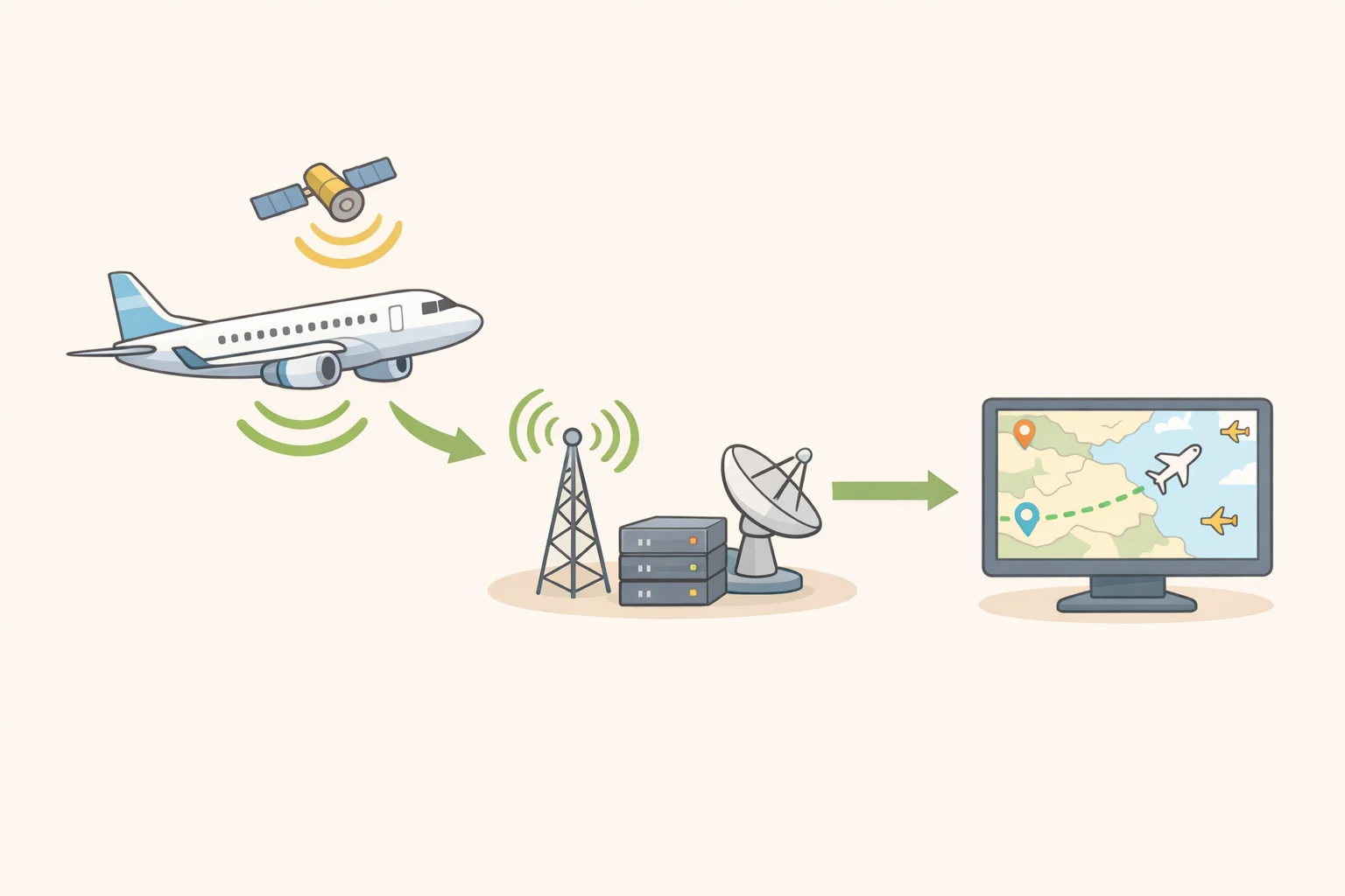
Before choosing a tool, it helps to understand what these trackers are actually doing, because the underlying technology explains most of the edge cases.
ADS-B stands for Automatic Dependent Surveillance-Broadcast. Equipped aircraft continuously transmit a radio signal broadcasting GPS position, altitude, speed, heading, and a unique identifier. Ground-based receivers pick up that signal and feed it to aggregators like Flightradar24 and ADS-B Exchange, which plot it on a live flight tracker map in near-real time. Think of it as the aircraft announcing its position to anyone listening, rather than a radar actively sweeping for it. The Flightradar24 Blog describes ADS-B as sending "a wealth of information about a flight including GNSS position, altitude, speed, vertical rate, track, and more."
That radio-based architecture has two important physical constraints. First, reception is strictly line-of-sight: radio waves don't bend around mountains or follow the earth's curvature, so a receiver in Denver can't pick up an aircraft flying below ridgeline in a canyon (Aerodata). Second, no ground receivers exist over the Atlantic or Pacific. That's simply not how physics works. Until earlier this year, mid-ocean flights vanished from consumer trackers entirely. FR24's integration with Aireon's space-based ADS-B network, hosted on Iridium NEXT satellites, now fills that gap for flights broadcasting ADS-B Out, enabling near-real-time tracking over open ocean (Flightradar24 Blog). ADS-B Exchange has no equivalent satellite layer (Aerodata).
For aircraft without ADS-B transponders, FR24 uses a fallback called MLAT, or Multilateration: it calculates position from the time difference of arrival of a transponder's radio signal across multiple receivers simultaneously, without relying on GPS at all (Flightradar24 Blog). MLAT is also how FR24 counters GPS spoofing in conflict zones, where jamming can push displayed aircraft positions to wildly incorrect coordinates. MLAT positions are less precise than GPS-derived ones, but as a correction for spoofed paths they're considerably more useful than nothing (Flightradar24 Blog).
Video of the Day
How to track flights live on Flightradar24

FR24 is available at flightradar24.com and as apps on iOS and Android. Open it and you get a live map populated with aircraft icons, each tagged with airline, altitude, and heading. Clicking or tapping any icon brings up a detail panel showing registration, operator, aircraft age, and sometimes owner, along with origin, destination, and recent flight path (OSINTBench). OSINTBench rates it as the best interface in the category, describing the map as fast, clean, and functional on mobile.
Finding a specific flight: The search bar accepts flight numbers (e.g., UA932) for airline routes, tail numbers for specific aircraft, or airport codes for departures and arrivals. Flight number is fastest for scheduled commercial routes; tail number is what you want when tracking a particular aircraft regardless of route.
What the free tier gives you: Roughly a five-minute delay on live position data (Aerodata). For checking whether a flight has landed or identifying something passing overhead, that's usually sufficient. Paid tiers, Silver at $2.99/month and Gold at $7.99/month, remove the delay and unlock up to 365 days of flight history (OSINTBench). ADS-B Exchange, covered below, shows live data with no delay and no subscription at all.
One map detail worth knowing: Aircraft shown in blue are being tracked via Aireon satellite data rather than a ground receiver; their positions update in 15-minute increments when outside terrestrial coverage areas (Flightradar24 Blog). Separately, a flight path that spirals or jumps erratically near a conflict zone is usually a GPS spoofing artifact rather than an actual route deviation. FR24 uses MLAT to calculate a corrected path where enough receivers are available, but in regions with thin coverage the displayed position should be treated as approximate (Flightradar24 Blog).
Why the plane you're looking for isn't showing up
Work through this sequence and you'll reach an answer quickly. A flight missing from any free tracker almost always comes down to one of six things: no ADS-B equipment, a geographic coverage gap, LADD or military blocking, a different feeder network catchment, a data delay artifact, or an aircraft type that was never reliably trackable to begin with (Aerodata).
Step 1: Does the aircraft have ADS-B Out? No ADS-B Out means no tracking. The FAA's ADS-B Out mandate, which took effect in January 2020, only covers aircraft operating in specific controlled airspace: Class A, Class B, Class C, and Class E above 10,000 feet MSL (Aerodata). Smaller general aviation aircraft flying beneath those thresholds aren't required to carry the equipment, and many don't. If you're searching for a small prop plane on a low-altitude flight, this is often the end of the investigation.
Step 2: Is it a commercial flight with a map delay? FR24's free tier runs about five minutes behind live. A flight that just departed or recently landed may simply not have appeared yet. Flights leaving coverage-thin regions, sub-Saharan Africa, central Asia, northern Canada, large portions of South America, may show up intermittently or only once the aircraft climbs high enough for additional receivers to pick up its signal (Aerodata).
Step 3: Is the aircraft in a geographic dead zone? Ground-based ADS-B reception is strictly line-of-sight. An aircraft flying low through a mountain valley can fall below the radio horizon for every receiver within 200 miles, and there's no workaround for that (Aerodata). Coverage is densest over Europe, the northeastern US, Japan, and Australia, and thins fast everywhere else. Over open ocean, FR24 provides coverage via Aireon satellite data; an ADS-B Exchange search over the same area will return nothing, since that service has no satellite layer.
Step 4: Is it a US-registered private jet? This is where the tracker works exactly as designed and still fails to show you what you want. The FAA runs a program called LADD, the Limiting Aircraft Data Displayed program, that lets aircraft operators request their registration be stripped from the data fed to commercial tracking services. The aircraft is flying and its transponder is broadcasting; the FAA simply removes the tail number from the data stream before it reaches FR24 (OSINTBench). If a specific US-registered business jet is simply absent from the map, LADD enrollment is the most likely explanation. The FAA LADD database is publicly searchable: a blocked registration won't resolve to a visible aircraft even in a targeted search (Aerodata).
Step 5: Is it a military aircraft? Military filtering varies by aircraft type and works differently from LADD (Aerodata). Most military aircraft don't broadcast ADS-B at all; they use encrypted IFF (Identify Friend or Foe) systems that civilian receivers can't decode, and US Air Force fast movers are largely invisible by design (Aerodata). Some military transport and logistics aircraft do appear on civilian trackers, but military aircraft are frequently filtered or may transmit false positions (OSINTBench). If the aircraft you're tracking is a fighter or government surveillance plane, no free tool will reliably show it.
When ADS-B Exchange is the right call instead
ADS-B Exchange has one characteristic that separates it from every other major tracker: it does not honor FAA LADD opt-out requests. FR24 and FlightAware strip blocked registrations from their displays. ADS-B Exchange takes the position that if a transponder is transmitting and within range of a volunteer receiver, the aircraft appears on the map (OSINTBench). For a private jet that should be visible but isn't on FR24, that's where to look.
The tradeoffs are worth understanding before switching. ADS-B Exchange runs on a volunteer receiver network with no satellite ADS-B, which means no oceanic coverage and noticeably thinner reach outside Europe and North America (Aerodata). Its interface is functional but rougher than FR24's, and mobile app support is limited (OSINTBench). The web map is completely free, live data, no delay, no subscription.
ADS-B Exchange also maintains a manually curated "Interesting Aircraft" list that labels known government, law enforcement, and surveillance aircraft as they appear on the map, something FR24 has no equivalent of (OSINTBench). For journalists or researchers tracking non-commercial aircraft with any regularity, that feature alone justifies keeping both tools bookmarked.
Feature comparison, per OSINTBench:
| Flightradar24 | ADS-B Exchange | |
|---|---|---|
| LADD filtering | Yes (blocks opt-out aircraft) | No (shows all transmitting aircraft) |
| Satellite coverage | Yes (oceanic via Aireon) | No |
| Free-tier data delay | ~5 minutes | None |
| Mobile app | Full iOS/Android | Limited |
| "Interesting Aircraft" labels | No | Yes |
| UI quality | High | Functional |
The practical decision framework
Use FR24 as the default for commercial flights, airport monitoring, and identifying aircraft overhead. If a plane is absent on FR24 and it's a US-registered private aircraft, confirm LADD blocking via the FAA database, then check ADS-B Exchange. If the transponder is transmitting within ground-receiver range, it will appear there (Aerodata; OSINTBench).
If the aircraft has no ADS-B Out equipment, is in a geographic dead zone, or is a military fast mover, neither tool will show it. That's a physics and policy boundary, not a gap someone forgot to fix.
The more durable insight is this: a missing flight almost always tells you something specific. The absence itself is a clue. Knowing which of those six categories applies is more productive than switching tools blindly, and considerably more productive than assuming the tracker is broken. Flight tracking failures are usually informative; the trick is knowing how to read them.
Go deeper: The Flightradar24 Blog publishes detailed technical explainers on MLAT and GPS spoofing mitigation. The FAA LADD database is publicly searchable at faa.gov for confirming whether a US registration has been blocked. ADS-B Exchange community forums cover volunteer receiver coverage by region for anyone trying to understand why a specific area shows gaps.